|
Maple Ridge Island History
Collaborative
Maple
Ridge Island History Main
Menu Hosted by: MapleRidgeLive.com About the History Collaborative Page
Menu Documents, Graphics, Resources Image of
The St. Moritz Club Plan Ariel
Photos Cobbosseeconte Lake in
Central Maine Documents,
Graphics, Resources Chain of Title to Maple Ridge
Island 1964 Dayken – Chick Island Deed Monmouth Tax Map with Island Detail Kennebec County
and Registry of Deeds Maple Ridge drive 50 Foot Right-A-Way (Note
reference in 1988 Deed to lot #25) 2018 Survey North Road and
Lot #95 History
of Maple Ridge Island Maple
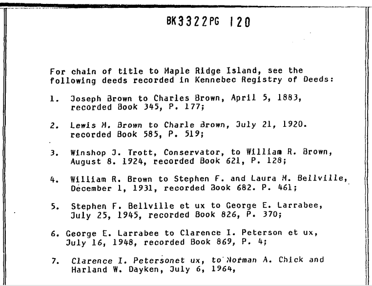
Ridge Island was unsettled but legally owned as early as 1883 as listed above
in the “Chain of Title to Maple Ridge Island” as seen in the 1988
Deed to Lot #25. 1948 St.
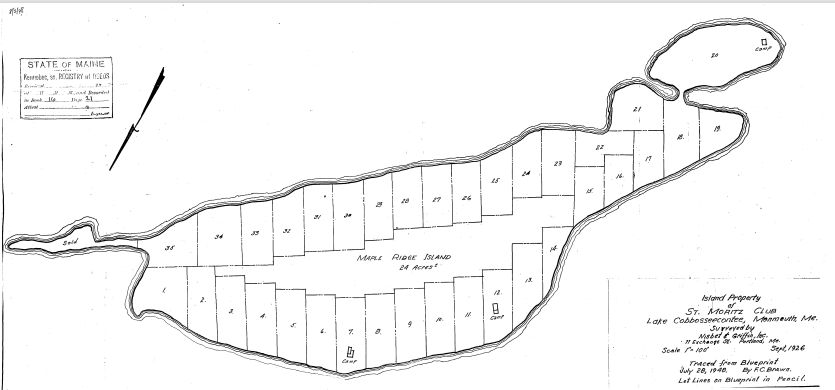
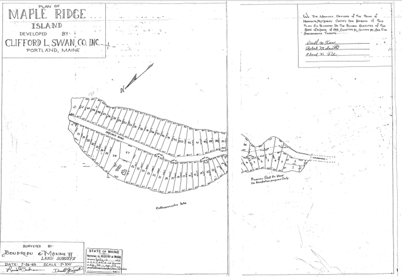
Moritz Club Plan The September
1926 Survey by Nisbet & Griffin Inc. 11 Exchange St, Portland, Maine was
the basis for the 1948 St. Moritz Club Plan
which was “traced from the blueprint” of the Survey which had “lot lines in
pencil”. The St. Moritz Club Plan is the earliest recorded description of
Maple Ridge Island based on a survey. The Plan shows
three camps on the Island with depictions of their locations. One of the
camps, shown on the Plan, is situated at the Southwest corner of Lot
#20. That camp is pictured in two of
the photos in the Muriel Minkowsky's Gallery of Original Pictures.
One of the images
in the gallery shows William Bergin SR standing on the porch in or about
1929. The other two camps identified on the Plan were on Lots #7 and Lot #12.
The origin of the three camps is of interest to the Collaborative. It is
known that the camp on Lot #20 was relocated from the mainland by
transporting it across the winter ice to the island. Image of
The St. Moritz Club Plan
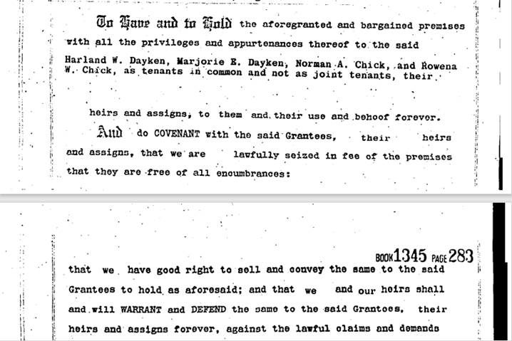
The 1964 Dayken – Chick Island Deed Development of the Island proceeded slowly
until 1964 when Harland Dayken and Normand Chick purchased Maple Ridge Island
from Clerence and Greta Peterson from New Hampshire. Dayken and Chick financed the construction of a
land bridge causeway with large a passthrough culvert connecting the island
to Cobbosseecontee Road on the mainland. The causeway was constructed by The
Cyr Construction Company in the summer of 1965 and several photos in Muriel’s
Gallery show the progress and completion of the Causeway. There are also photos of a mishap as one of
the construction trucks went off the causeway into the lake. The 1965 Clifford L. Swan Plan The Clifford Swan Plan recorded in 1965 shows the layout of the
50-foot waterfront lots to be sold by Dayken and Chick. An island right-of-way for Daychick Road
(renamed Maple Ridge Drive) is referenced in the 1988 deed to Lot #25. This Deed is included for its list of
previous owners of Maple Ridge Island listing transfer dates and owners until
Daken and Chick acquired the Island from the Petersons in 1964. See an image
of the Deed with reference to the Maple
Ridge Drive 50 Foot Right-A-Way and the “chain of title to Maple Ridge
Island” dating back to 1883. Chain of
Title to Maple Ridge Island (Book 3322, Page 120 KCRD) (Clipped
and displayed here from the 1988 Deed to Lot #25)
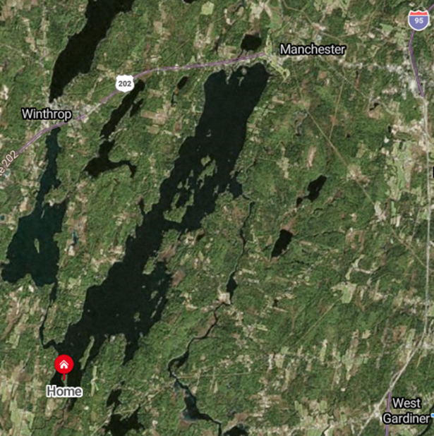
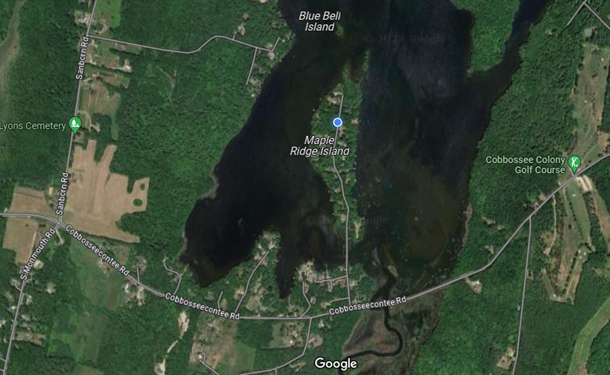
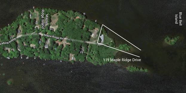
Location
of Maple Ridge Island Aerial
view of the entire Cobbosseeconte Lake from Maple Ridge Island in the South
to Manchester, Maine in the North
|
Image
of The July 8, 1964, Harland Daken
and Normand Chick
Deed
|
|
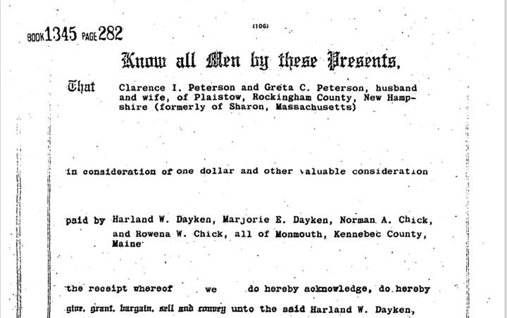
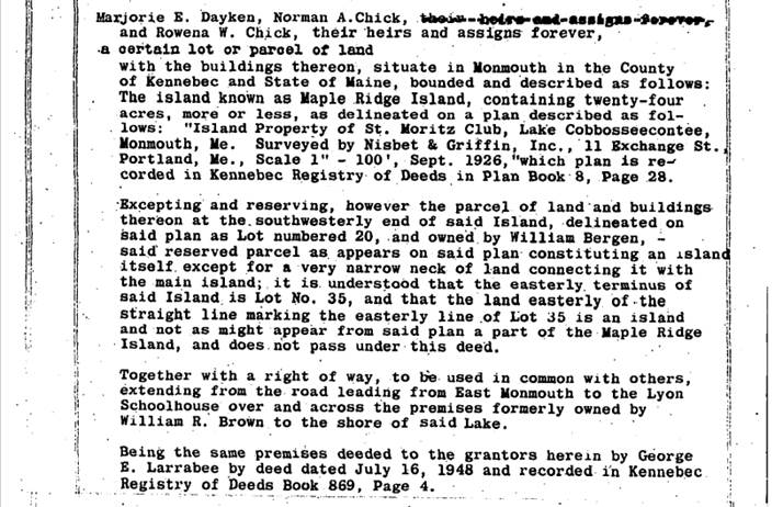
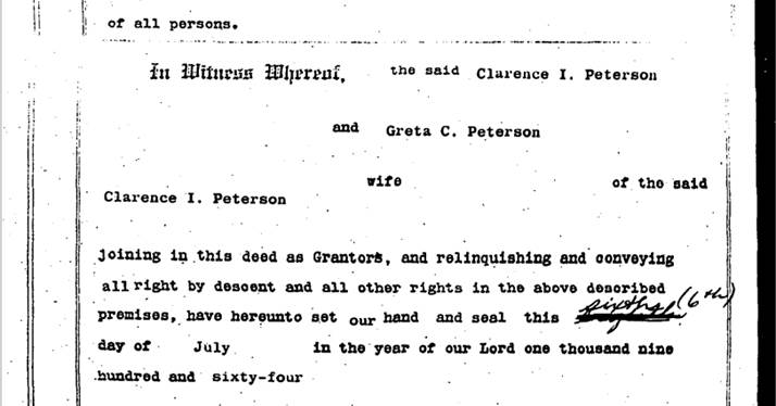
The 1964 Dayken
and Chick Deed to Maple Ridge Island
|
The July 8, 1964 Harland Daken and Normand
Chick Deed to Maple Ridge Island references The 1948 ST. Moritz
Club Plan as the foundation of its description of Maple Ridge
Island and is referenced to Book 869, Page 4 at the Kennebec County
and Registry of Deeds |
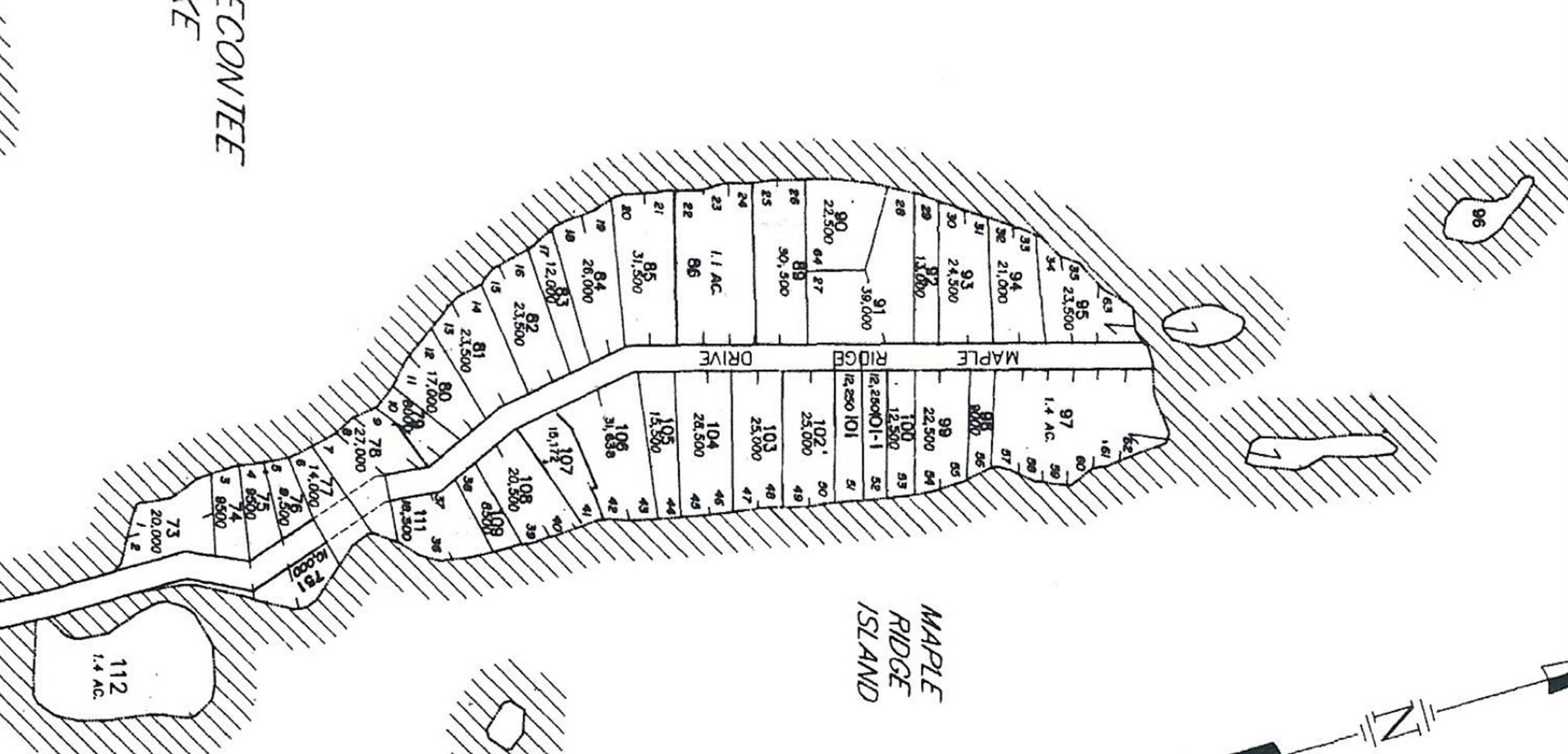
Monmouth, Maine Tax Map 24
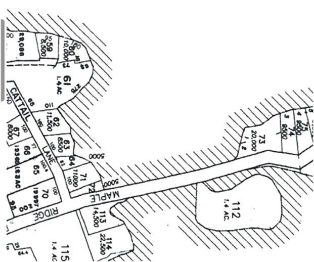
Tax Map Image Detail of The Island
Monmouth
Tax Map 24 displays Maple Ridge Island with the current Lot Numbers that
combined most of the 50-foot lots on the Swan Plan into 100-foot lots to comply
with the Monmouth zoning regulations. Map 24 lists the legacy 50-foot Lot
Numbers with the modern current Lot numbering.
For example: at the south end of the Island Lot #20 on the 1948 St. Moritz
Club Plan with the camp noted (not shown on the Swan Plan) is now Lot #112 on Tax Map 24. At the North end of the Island Lots #34, 35
and 63 on the Swan Plan are now combined on Map 24 as Lot #95.
The Causeway to Cattail Lane
|
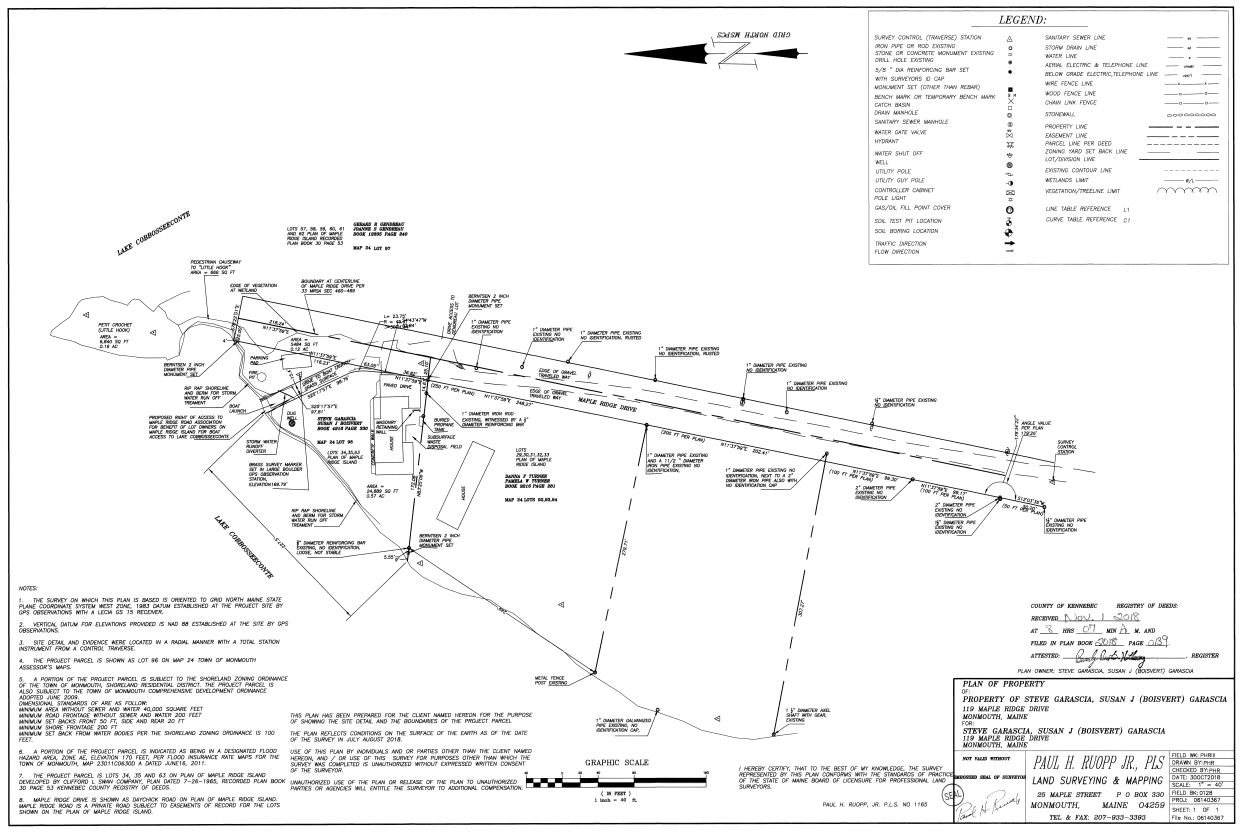
The 2018 Survey The 2018 Survey
defines the North end of Maple Ridge Drive with its centerline and two
sidelines of the deeded fifty-foot road right-of-way from the top of the hill
to the end of the road as it terminates in the wetlands. The Survey complies
with the 1965
Clifford Swan Co. Plan as surveyed by Boudreau and Manne in that same
year, 1965. The survey documents
an important distinction between the defined 50-foot Right-of- Way and the
actual “Traveled Way” the road makes as it is on the ground; noting that the
actual road is not anywhere 50 feet wide and that the Right-of-Way extends on
to the abutting Lots along the entire road. See the “Traveled
Way”, of the actual road, marked off on the Survey as dashed lines mostly,
but not always, well within the 50-foot Right-of-Way. See Book 2018 Page
139 at the Kennebec County and Registry of Deeds for a copy of the original
2018 Survey. Survey Error There is an error
on the Survey which incorrectly labels Lot #95 as Lot #96. The registered Deed and the Monmouth Tax
Map #24 both identify the Lot as #95. See the Image of The Survey below Select this Link to download a full copy of the Survey Or this one: Link to see an image of the Survey
|
E:\mapleridgelive.com\MRI_History_Collaborative\Maple_Ridge_Island_History.htm
End of Page