|
Homeowner’s Guide 119 Maple Ridge Drive, Monmouth,
Maine About The
Survey-Lot 95-Monmouth Tax Map 24 Hosted by: MapleRidgeLive.com About The Survey of Lot 95 on Monmouth Tax Map 24 Page Menu Important Note about the Survey
Lot Numbering Error Download a PDF Copy of the Lot#95
Survey The three Tri-Corner Survey
Monuments IMPORTANT NOTE: A Lot Numbering Error was made on The
Survey · A Lot Numbering Error was made on
the Survey where Lot #95 was mistakenly marked on the survey as lot #96. The
accurate lot number for the address of 119 Maple Ridge Drive is Lot #95. · The land and waterfront shoreline
at 119 Maple Ridge Drive are identified as Lot #95 on the Monmouth Tax Map
#24. Note that the Tax Map assigns Lot #96 to Blue Bell
Island which is just North of Maple Ridge Island. · See the highlighted Lot Numbering
Error on this Survey Detail with
Highlighted Lot Number Error (Lot 96 should be Lot 95) Reference
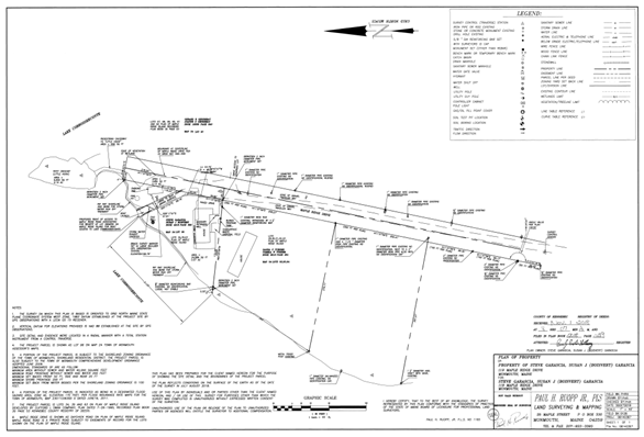
Documents and Survey of Lot #95 See a static image of the survey below. The
survey is registered in Book #2018 on Page #139 at Kennebec County
Registry of Deeds. Use this
link to access a Dynamic PDF
virtual copy of the Site Survey of
Lot #95
and the Centerline and Sidelines Survey of Maple Ridge Drive from the top of
the hill to its North endpoint at the bottom of the hill as it encounters The
Wetlands. Note that
Maple Ridge Drive (previously existing as Day Chick Road) traverses over a
fifty feet (50 Ft.) wide right-of-way with each lot owning their twenty-five
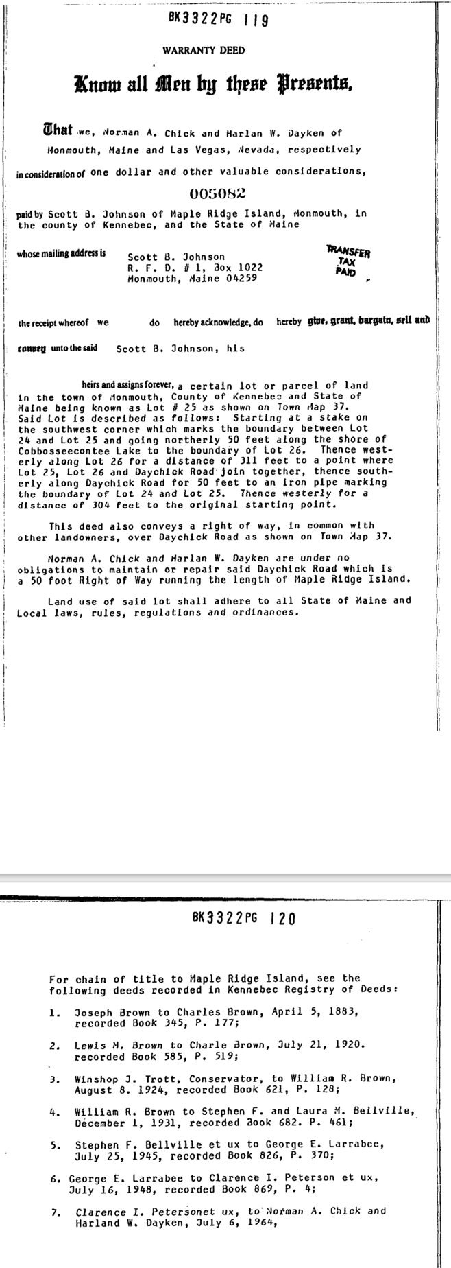
feet (25 Ft.) of the road to the center line of the right-of-way. The fifty feet (50 Ft.) wide right-of-way
is described in Book #3322, on Page #119 as a (PDF) of the Recorded Dee with
useful “Chain-of-Title to Maple Ridge Island. Or See
image of deed below. Note
that this deed includes the recorded deed history of Maple Ridge Island with
Book and Page annotations for research access to the original recorded deeds
at the Kennebec County
Registry of Deeds. The Survey refers to an Elevation Marker and the three (3) Tri-Corner
Survey Monuments set in the ground
at each of the three (3) angles of the delta shaped Lot #95. The Survey also established the sidelines
and centerline of the fifty-foot (50 FT) wide Right-of-Way (ROW) of Maple
Ridge Drive. The West Sideline is marked by a line between the two (2)
western Tri-Corner Survey Monuments described below. Note
that the actual “traveled way” of the road is not fifty feet wide (the actual
road is only fifteen – twenty feet wide) and deviates significantly left and
right of the centerline of the ROW. As
each Lot on Maple Ridge Drive is defined to the centerline of the ROW and the
actual road does not occupy the entire ROW the actual sidelines of the ROW
are not well defined. As the ROW
becomes unusable for vehicle passage at the bottom of the hill, the actual
road essentially ends as it terminates at the boundary of Lot #95 to the West
and Lot #97 to the east (as the ROW runs into the wetlands of the lake). Note also that the accessway to the Boat Launch on Lot #95
deviates to the Northwest as it turns away from Maple Ridge Drive and
traverses over the private property of Lot #95 and is not a “Right-of-Way” to
the Lake. Use of the Boat Launch on Lot #95 is by permission only. The First
Page of this reference deed identifies the fifty-foot Right-of-Way for Day
Chick Road (later renamed as Maple Ridge Drive. The second Page of the Deed lists the
complete “Chain-of-Title” to Maple Ridge Island. The
Reference Deed
Static
Image of The Survey
Tri-Corner
Survey Monument Markers The
Survey identifies three Tri-Corner Survey Monument Markers The
physical placing of the three Survey Monuments at each Tri-Corner of Lot #95
ties the Survey to the actual ground of the lot and defines the boundaries of
the Lot by establishing the sidelines. Lot #95
has only three (3) sidelines or boundary lines. The best-defined boundary Lot
#95 is its Western boundary which is its shoreline with Cobbosseecontee Lake. The
Southern tree-lined boundary between the two homes is obvious and the
Southeast Monument is easily located near the lamppost. The
Northeast Monument is not hard to find either but the line between the two
markers is hard to see and is complicated by the pavement and wandering edges
of the wetlands and the abstraction of the Right-of-Way (Row) with its
sidelines and its Center line. The
survey clearly defines the fifty-foot (50 FT) ROW as well as the “Traveled
Way” of the actual road which is nowhere fifty feet (50 FT) wide and does not
follow the center line of the ROW The
significance of the centerline is that each lot on the island is continuous
to the centerline and is responsible for maintaining the ROW to its
centerline as it travels across the twenty-five feet (25 FT) of each abutting
lot either side of the ROW. In the
case of Lot #95 the ROW encounters wetlands impassable by vehicles as it
meets with Lots #95 to the West of the ROW and Lot #97 to the east of the
ROW. Δ
Back to description of the Markers To find
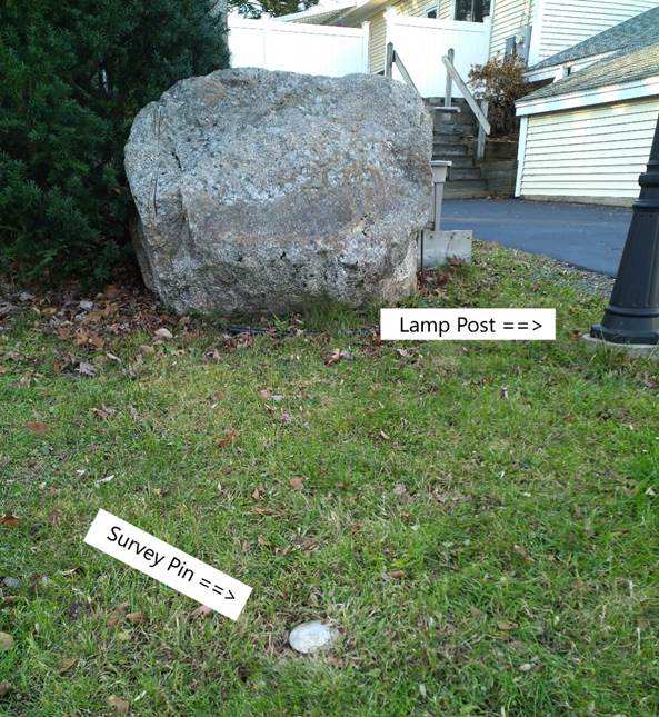
the Southeast Tri-Corner Monument · The Southeast
Survey Monument is the easiest of the three Tri-Corner markers to find. · The monument is in the grass by the side of the road by the Lamppost and
in front of the bolder near the Lamppost. See the
photo below. The
Southeast Survey Marker
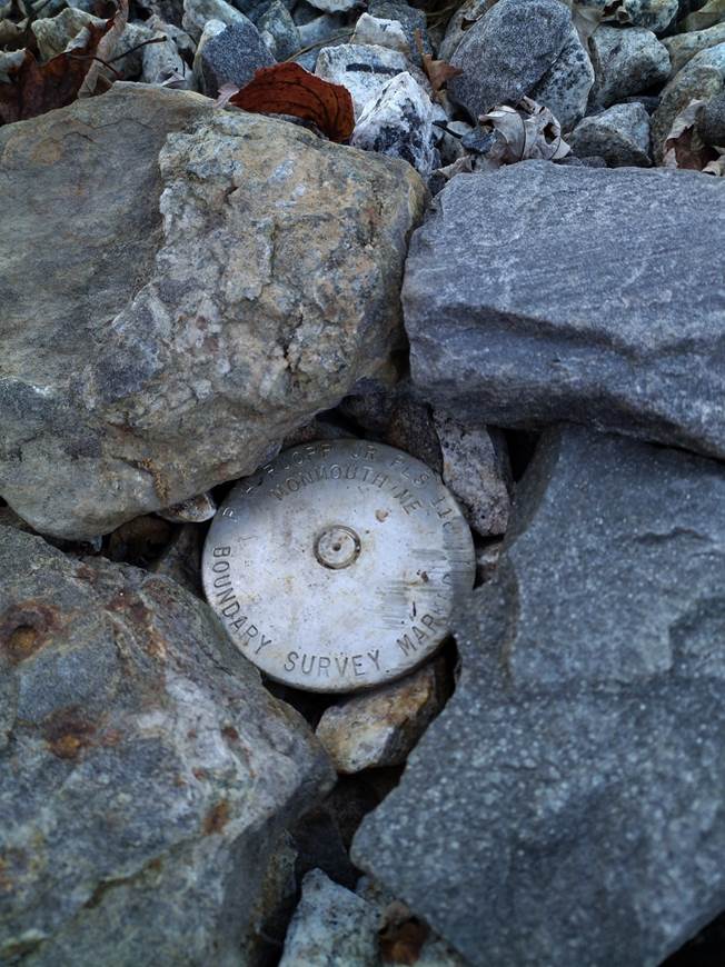
Δ Back to description of the Markers To find the Southwest Tri-Corner Monument The Southwest Survey Monument is the most
difficult to find. From the Southeast Monument near the Lamppost
just in front of the large bolder, follow the South Side Line West by taking
the stairs up toward the deck. At the deck move left staying on the ground and
pass along between the two homes. At the end of the deck walk along the edge of
yard toward the water. Look for
the Survey Monument just before the ground turns down sharply toward the
waterfront shoreline. See the photo below with the Legacy metal bar and
wooden stake and the new Survey Monument with identifying markings on its
disk cap. Southwest
Corner Marker
Δ Back to description of
the Markers The
Northeast Corner Marker
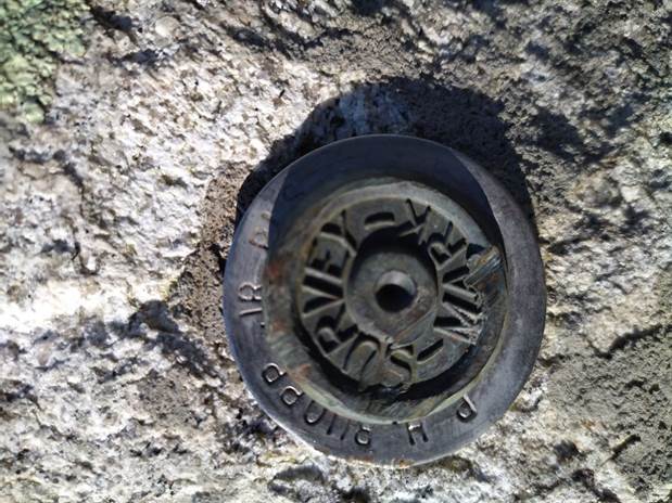
The Elevation Marker at 169.79 inches above
Mean Sea Level The elevation marker is
essentially at the level of the front lawn and is about three feet (3 FT)
above the mean high water mark when the lake is at “Full Pond” as defined and
controlled with the retention dam managed by the Cobbossee Watershed District.
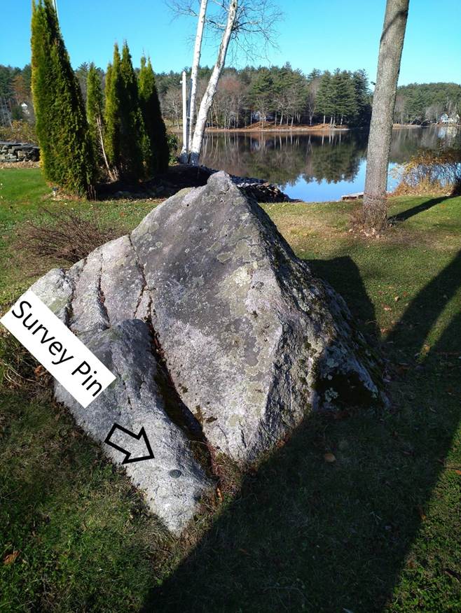
The Elevation Marker as discribed in the
Survey is a brass Survey Mark placed in the low corner of the bolder at the
RV-Pad. See the photos for reference to its location. Closeup
of The Elevation Marker
Overview of The Bolder with The Elevation Marker at its lower corner as
seen in this view. |
|
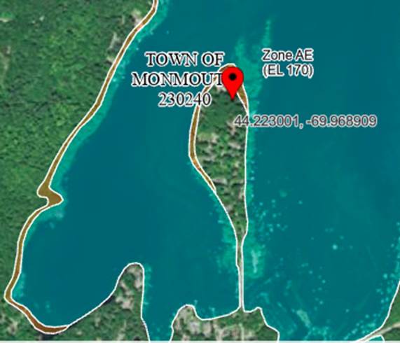
Flood Plane Survey Pin Suggested
Survey Maintenance Perform an annual inspection of the three (3) “Tri-Corner
Monuments” as frost can heave up pins; and annotate the Hard Copy of the
Survey with significant additional structures and / or features not shown on
the survey. Note: “The Large Shed was constructed in 2022 after the 2018
Survey and has been added to a Hard Copy of the Survey. FEMA
Floodplain Map Section in Zone AE FEMA Flood Zone AE is assigned to the 100 Year Flood Risk
Zone as a Special Flood Hazard Area (SFHA).
Zone AE is assigned to areas near the high-water mark of adjacent
bodies of water. The Ruopp Elevation Survey Pin is more than three feet above
the “Annual High-Water Mark” set by the Caboose Water Shead District in
control of the “Outlet Dam” that sets the level of Caboose Lake. Lot #95 is
not required to have mandated flood insurance and was not a mortgage lender
requirement. FEMA Flood Plane Map Image
Refrensens The
“Boat Launch Ramp” on Lot #95 A HANDBOOK
FOR SHORELAND OWNERS Page File Information G:\mapleridgelive.com\119MRD_WS\119_Maple_Ridge_Drive_Location\Lot_95\2018
Survey_Lot_95\Lot and North Road Survey.htm |
|
|